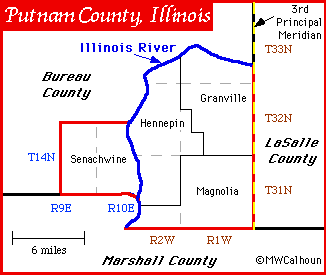

Township designations in the Federal Township-Range Survey System are the numbers along the bottom and sides in blue and brown.
Townships on the west side [blue labels] of the Illinois River are measured from the 4th Principal Meridian.
Townships on the east side [brown labels] of the Illinois River are measured from the 3rd Principal Meridian, which forms the eastern boundary of Putnam County.
[More about the Federal-Towship Range System of Land Survey.]