In May 1812, an act of Congress was passed which set aside bounty lands as payment to volunteer soldiers for the War against the British (War of 1812). The land was set aside in the present states of Arkansas, Michigan and Illinois.
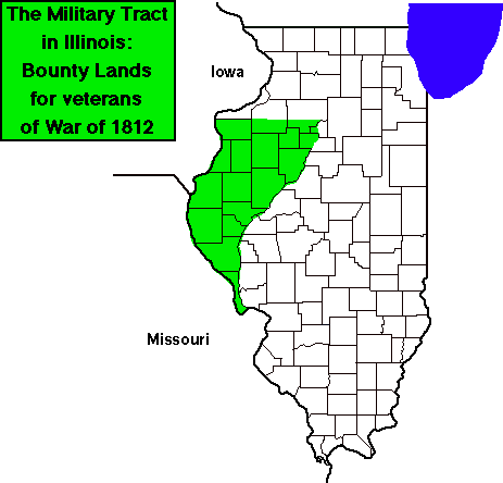
The bounty land in Illinois is located in the western part of the state between the Illinois and Mississippi Rivers [see map below on this page]. It includes all of the present counties of Adams, Brown, Calhoun, Fulton, Hancock, Henderson, Knox, McDonough, Mercer, Peoria, Pike, Schuyler, Stark, and Warren Counties. It also includes part of Henry and Bureau Counties, and those parts of Marshall and Putnam which are on the west side of the Illinois River. The area comprises about 5.4 Million acres. Approximately 3.5 Million was deemed fit for cultivation and was set aside for military bounties.
The tract was surveyed in 1815-1816 and opened to settlement. Then warrants for land were issued by the government. Many of these land grants can be found by searching Illinois Public Land Sales. For an explanation of the way the land in these grants are surveyed, see Federal Township-Range Survey System.
Reference: The History of McDonough County, Illinois compiled by R. Chenoweth and S.W. Semonis, sponsored by the McDonough Co. Genealogical Society, 1992, Curtis Media Corporation, Dallas, TX.