 Map of the Atlanta Campaign [83 Kb JPG]

part of a volume entitled History of the Ninety - Third Regiment Illinois Volunteer Infantry: From Organization To Muster Out --Statistics Compiled by Aaron Dunbar Sergeant, Company " B", Revised and Edited by Harvey M. Trimble, Adjutant
Submitted by Jeffrey MacAdam, to whom every reader should be grateful.
| Table of Contents | Previous Page | Next Page |
Part 1 of 5 for Chapter 7.
On the 3rd day of October, during the afternoon, there was some excitement among the troops at Allatoona, caused by the reported movements of the Confederate army below. All of General Hood's forces had crossed the Chattahoochie River, and the main body of his army was in the neighborhood of Lost Mountain. General Stewart's corps, however, was moving to strike the railroad between Marietta and Allatoona. Marietta is about twenty miles below Allatoona. Some cannoning was heard during that afternoon. Precautions were taken by our garrison to guard against a night attack by the enemy. On the morning of October 4th, the situation was strongly indicative of a battle at Allatoona; but just when it might come no one was able to determine. Big Shanty, a railroad station, was located about midway between Allatoona and Marietta; and Ackworth, another railroad station, was located about midway between Allatoona and Big Shanty. Early in the day, heavy firing was heard in the direction of Big Shanty, and later in the neighborhood of Ackworth.
During the day, both these places were taken, and the garrisons, consisting of about four hundred men, were captured. The railroad was torn up and the telegraph lines cut at both places. The smoke of the fires of destruction along the railroad was seen all day. At night, the situation at Allatoona was very tense. No one any longer doubted that a severe battle would be fought there the next day. New rifle pits were made, and our defenses were otherwise strengthened as rapidly as possible. From Vining's Station, during the day, General Sherman sent a signal message to the officer of the signal station on Kenesaw Mountain, which was repeated from there, over the heads of the enemy, to the signal officer at Allatoona, and from thence, by telegraph line, to Brig. Gen. John M. Corse, at Rome, Georgia, by which General Corse was ordered to move immediately with his command to Allatoona. General Corse commanded a division. General Sherman said: "If he (Hood) moves up to Allatoona, I will surely come in force." Another message, sent in the same manner, said: "Corse, Rome, Georgia:--Move with your command to Allatoona. Hold the place. I will help you.--Sherman."
Map of the Atlanta Campaign [83 Kb JPG]
This was the message that suggested the Gospel hymn, "Hold the fort, for I am Coming." But could he get there? His most advanced troops could scarcely pass Marietta that night; and all of them were well nigh exhausted, having marched almost continuously for three days and nights. It really seemed that the enemy "had the move on him." Allatoona at once became the center point of interest and attention, not only to and of the enemy, nut to and of our army as well.
There were more than a million rations stored there; and only just across the Etowah River, five miles farther north, there was a government herd of nine thousand cattle. If the enemy should capture or destroy all these rations and cattle, the great Atlanta campaign might even yet result disastrously. And more than that, the campaign across Georgia, the "March to the Sea," might never be executed and its great results achieved. General Sherman now realized, no doubt, that it was an error to have left the bulk of the supplies for his army so weakly defended.
The garrison at Allatoona, Lieut. Col. John E. Tourtlelotte, commanding, consisted of the Ninety-Third Illinois, the Fourth Minnesota, the Eighteenth Wisconsin, and 15 men of the Fifth Ohio Cavalry, in all about 905 men, and the Twelfth Wisconsin Battery, of about 60 to 80 men. This battery had four Rodman rifled cannons, ten-pounders, and two brass pieces, twelve-pounders. It was not to be wondered at that General Sherman became extremely solicitous when he learned, on the 4th inst., that the whole Confederate corps of Lieut. Gen. A. P. Stewart was within ten to fifteen miles of Allatoona, within easy striking distance of that million of rations and those nine thousand cattle. But nothing in war was impossible to General Sherman. So, now, he was equal to the emergency. He sent a signal message, straight over General Stewart's head, to General Corse, at Rome, telling him to reinforce Allatoona, and to hold the place. Rome was about thirty miles away, by rail. General Corse reached Allatoona, by rail at 12 o'clock midnight on the night of the 4th. He brought with him the Thirty-ninth Iowa, the Seventh, Twelfth and Fiftieth Illinois, and two companies of the Fifty-seventh Illinois, in all 1,054 men, and 165,000 rounds of ammunition. These troops were a part of Colonel Rowett's brigade, and Colonel Rowett, of the Seventh Illinois, was in command of them. General Corse immediately assumed command of all the troops at Allatoona. The entire force was now 1,959 men, beside the battery, and, with those, about 2,030 men all told. Another train, carrying more troops of General Corse's division was derailed, and failed to reach Allatoona before the battle. That night the command slept under arms. All knew ;that the morning reveille would be sounded with muskets, on the picket lines, and that it would call them to desperate battle. All knew that before the setting of another sun many would fall to that sleep from whence no reveille for sound of bugle could ever again call them to arms and to battle. And yet, they slept!
At Allatoona, Georgia, there is a rugged mountainous ridge, which is cut and carved, in many different directions, down its sides and across its top, by ravines and deep gorges. Spurs and peaks rise above its average level to different heights and in various forms. In many places it is covered with heavy timber, and in others with a dense covering of smaller growth. Looking to almost any point of the compass, the scenery is picturesque, and from some of the higher peaks the limits of vision are more than twenty miles away. Hills, ravines and valleys, and winding streams, and forests and fields, and dense jungles of undergrowth and vines, all combine to produce many views that arrest attention and command admiration. The village of Allatoona, then containing no more than six or seven houses, was located west of the railroad, on the south side of the hills, in the edge of the valley of Allatoona Creek. The Allatoona range of mountains rises a few miles north of the village; and away off to the east much greater mountains lift their heads into plain view. Allatoona Creek, which has its source at Lost Mountain, about fifteen miles south of Allatoona, flows, first, in a course north-northwest, then gradually curves to north-northeast, then runs due north to and under the railroad at a point about two miles south of Allatoona, then curves to the west and back again to the east, making the form of an open letter C, with the upper line extended beyond the lower, then flows north-northwest, passing a half mile east of Allatoona, from whence its general course bears a little west of north, but with many windings and short turns through the mountains, to a point a little west of north from Allatoona and due east from Cartersville, and from thence, making a sharp turn, it flows in a course west-southwest to a point near the railroad, and from there southwest to its confluence with Pumpkinvine Creek, about three miles due south from Cartersville. Pumpkinvine Creek heads about twenty miles southwest from Lost Mountain, and flows, in its general course, but with much winding and many short turns, a little north of northeast, almost directly toward Allatoona. About three miles from Allatoona it turns sharply to a course south-southeast, and from thence, making another short turn, it flows northeast to the hills just west of Allatoona. Here, turning to the left, it forms the half of a circle about a mile in diameter, and flows back in a southwesterly course to a point again about three miles from Allatoona and within about a half mile of the point mentioned above as being three miles from that place, thus, nearly surrounding a tract of land much like the shape of an egg with a small portion of the big end cut away, the smaller end of which was within a half mile of Allatoona. From the last point above mentioned, it flows northwesterly to its confluence with Allatoona Creek, three miles south of Cartersville. These two creeks form the Etowah River. Fox Creek rises about nine miles east-southeast from Allatoona, and flows west- northwest, and empties into Allatoona Creek less than a mile southeast from Allatoona.
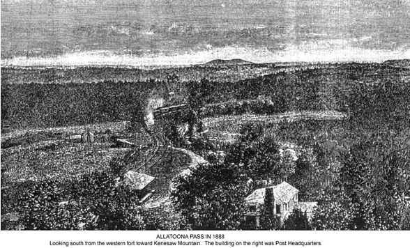
The Western & Atlantic Railroad, in its general course from Cartersville to Marietta, runs nearly southeast. From a point a little more than a mile west of Allatoona, it runs in a course east-northeast, then makes a curve to the right, resembling the side of a horseshoe, about three-quarters of a mile long, and then describes a greater curve, equal to the half of a circle about a mile and three-quarters in diameter, the course of which is southwest, south, southeast and east, to a point about two miles south and a little east of Allatoona. These two curves make a figure resembling the letter S with both curves reversed, the lower curve being a little more than double the size of the upper one, and the upper one being somewhat elongated. Allatoona is located about a half mile from the upper end and about a quarter of a mile from the lower end of the first curve. The middle third of the first curve is in a cut, through the ridge, between two hills, eighty feet through earth and ninety-five feet through rock, making it one hundred and seventy-five feet deep.
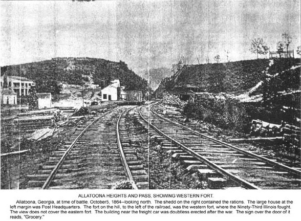
When General Sherman's army was advancing on Kenesaw Mountain, in June, 1864, two small forts, or redoubts, were constructed at Allatoona, under the supervision of Col. O. M. Poe, United States Engineers, who was then a member of General Sherman's staff. One of them was located on a hill about north-northwest from the village of Allatoona, and about sixty feet west of the railroad cut. It had six sides and six angles, and was about seventy-five feet long and sixty feet wide. The other was located on a hill about northeast from the village, and about six hundred and seventy-five feet east of the railroad cut. It was nearly square, and averaged about sixty feet long and fifty feet wide.
 Allatoona Heights and Pass [123 Kb JPG]
 Allatoona Pass in 1883 [116 Kb JPG]
These forts were so located that each could afford the other some support; and the two protected the warehouses where the rations were stored. There was a lower hill, between the two mentioned above, about one hundred feet east of the railroad cut. The railroad cut was about sixty feet wide. There was a foot-bridge, four feet wide, over the railroad cut, at a point about seventy-five feet north of a direct line between the two forts. It was ninety-five feet above the railroad tracks, at the top of the rock strata. Running due west from the northwest corner of the eastern fort, and refused in a curve, toward the south, at the west end, there was a line of intrenchments, about three hundred and thirty feet long. Covering the northwest slope of the lower hill, close to and on the east side of the railroad cut, there was another line of intrenchments, with four unequal sides, like the half of an irregular octagon, in all about one hundred and eighty feet long. About west-southwest from the western fort, and five hundred and eighty feet distant therefrom, there was still another line of intrenchments, about two hundred and seventy-five feet long, constructed upon irregular curves, across and covering the Cartersville road, about equal distances on each side of it. The north half of those intrenchments was west of the head of the ravine hereafter mentioned, at the top of the rise on the west side of the ravine. Farther out, on both sides of the Cartersville road and toward the southwest, the ground was considerably higher, and was covered with heavy timber. There were rifle-pits around each of the forts, close up against the outside base of the walls; and there was also a rifle-pit which extended from the western fort, in a southerly direction, about ninety feet, to the cut made in the side of the hill in the construction of the public highway leading from Allatoona to Cartersville. There was a house, and several outbuildings, about two hundred and eighty feet west-southwest from the western fort. That house was headquarters of the Ninety-Third Illinois.
There was a smaller house about sixty feet north of the western fort. There was also a large double house on the lower hill, about one hundred feet east of the railroad cut, nearly on a direct line between the two forts. That house was headquarters of the Fourth Minnesota. The warehouses, where more than a million of rations were stored, were located just east of the railroad at the south end of the railroad cut. Immediately west of the house first mentioned, was the head of a deep ravine which extended northward until it merged into the valley through which the railroad passed some considerable distance above the railroad cut. The public highway leading from Allatoona to Cartersville, as it climbed up the ridge, was cut deep into the side of the hill on which the western fort was located. Its first course was about west-northwest, then it formed two curves, like an elongated letter S, and then two lesser curves of similar form, and just beyond the outer line of intrenchments resumed its first course again. Where it passed the head of the ravine mentioned above, this road was laid on the crest of the ridge that formed the northern boundary of Pumpkinvine Creek Valley. Between the head of the ravine and the south slope of the ridge the road was not more than four rods wide. This point was about three hundred feet from the western fort. Another road, known as the "New Fort" road, branched from the one last above mentioned, at a point about six hundred and forty feet west from the western fort, and ran in a southwesterly course. The public highway, known as the Marietta road, left Allatoona in a course about southeast, and held about the same direction to within a short distance of Ackworth. About a quarter of a mile from Allatoona, another highway, known as the Dallas road, branched from the Marietta road, and ran, first, southwest, then nearly south to and across the railroad, and then nearly southwest again, towards Dallas. Another public road leads out of Allatoona in a course nearly northeast, then turns a curve to the north and north-northwest, and passes up onto and over the ridge at a point about half-way between the eastern fort and the railroad cut. There was no timber on the tops or sides of either of the hills on which the forts were located. The same was true of the ravine and the ridge west of the western fort, to the distance of fifty or sixty rods.
Everything had been cut down, and mostly cleared away, to afford greater range for the artillery. There was some small trees and scattered brush on the lower ground northwest from the western fort. Across Allatoona Creek, southeast from Allatoona and three-quarters of a mile away, there is a long mountain slope, sparsely covered with timber. A little farther away the ascent becomes steeper and steeper up to the crest of a high mountain. Beyond the sloping foot of this mountain there was a heavy growth of timber. Allatoona Creek Valley, averaging about a mile in width, passes around from the west side to the north end and northwest of the mountain slope, and thence sweeps north around the hills at Allatoona. Pumpkinvine Creek Valley lies southwest of Allatoona, and is separated from the valley of Allatoona Creek by only a very slight rise of ground, barely perceptible to the eye. They so nearly merge into each other that the casual observer would not discover that there are two separate valleys.
The foregoing minutes description of this battlefield, and its surroundings, is given here, because the battle fought there was so hotly contested, and was of such importance in its results, that it was immediately recognized as a great battle, and as one of historic import. Great things depended upon the ultimate issue of it, upon a Federal victory there. The map which is here inserted, in connection with this description of the field, will enable the careful reader to fully appreciate the splendid valor of the federal troops, who held Allatoona Pass, and won a most glorious victory, against an overwhelmingly superior force, on the 5th day of October, A. D., 1864.
| Table of Contents | Previous Page | Next Page |
[93rd Illinois Infantry Home Page]
Contact the webmaster
Web Hosting donated by: Infobahn Outfitters, Inc.
This document: http://illinois.outfitters.com/illinois/history/civil/cw93-hist-ch7a.html
Last update: Thursday, 11-Jan-1996 15:23:29 CST