For the sake of illustration, let's assume that you have searched the Illinois Public Land Sale database to find land purchased by Richard F. Beadles. [see note]
The system returns:
Purchaser:      BEADLES RICHARD F         Record ID:      424214
  Date:           03/24/1862
  Acres:          80
  Price:          $11.00
  Type of sale:   Railroad     (RR)
  County:         41
  Section:        8                         Section Part:   NWNE
  Township:       01S                       Range:          01E
  Meridian:       3                         Purchaser Res:
  Arch. Vol. No:  791                       Vol. Page No.:  087
  Cash warrant code:                        Record corrected: 0
This record shows a discrepancy between the acreage and the land description. The land description is the northwest quarter of the northeast quarter of section 8 or 1/16 of the 640 acres in the section. This is 40 acres not 80. For remainder of the discussion, assume that the acreage is 40. The database says that the land description is:
Northwest Quarter of the Northeast Quarter of Section 8 in Township 1 South, Range 1 East of the Third Principal Meridian [Jefferson County]
Step 1. Find the Third Principal Meridian and the Baseline which crosses it on the map of Illinois.
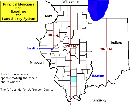
Step 2. Note that the land is in Township 1 South [T1S], Range 1 East [R1E], which is the first township south of [below] the Baseline and the first township east [right] of the Meridian.
Step 3. The database reported that the land was in Jefferson County, so you should expect to be in the box marked with the J.
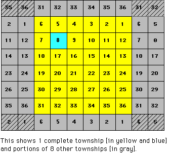
Step 4. On the township map provided, locate Section 8 in T1S R1E.
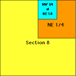
Step 2. Now use the section map provided to first find the Northeast Quarter of Section 8 [orange]. Then find the Northwest Quarter of the Northeast Quarter [blue].
Step 6. Pat yourself on the back!
The land is in Grand Prairie Township of Jefferson County, Illinois, about 1.2 miles east of US Rte 21 where it runs along the Jefferson-Washington County line and 1 mile south of the Jefferson-Marion County line. The database shows the land as a railroad purchase which was land given to the Illinois Central railroad and sold by them. A recent map shows that a line of the Illinois Central Railroad runs through the land.
Maps If you're looking for maps of Illinois, you might try the Illinois Atlas and Gazetteer [DeLorme Mapping, PO Box 298-6600, Freeport, ME 04032 - DeLorme's WWW site]. This has about 80 pages of color topographical maps on the scale of 1:120,000 [1 inch=2.4 miles]. The maps show and name townships (but NOT in the Township-Range System described above), roads, communities, railroads, waterways, etc. I have made a lot of use of my copy.
Three drawbacks of the atlas: (1) Most of the roads are drawn at nearly the same width, so it's difficult to tell what type of road surface you will find. (2) The township-range markings are not used. (3) The page breaks can make it difficult to see what is adjacent.
DeLorme also has maps for other states. I frequently see them in the travel-geography sections of bookstores as well as in some libraries.
Last update: Friday, 14-Jul-2000 15:56:25 CDT