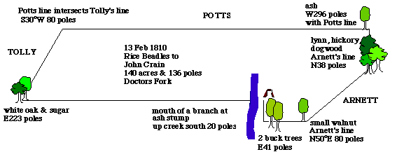
13 February 1810. Rice BEADLES of Lincoln Co., Ky sells 140 acres and 36 poles of land in Mercer County on Doctors Fork to John CRAIN for 200 pounds. Land bounded as follows...: [Ref. 1]
Beginning at the mouth of a branch at an ash stump
thence up the creek S 20 poles to 2 beach
thence east 41 poles to a small walnut in Arnett's line
thence north 50 east 80 poles to a linn hickory dogwood in said line
thence north 38 poles to an ash
thence west 296 poles with Potts's line till it intersects with Tolly's line
thence south 30 west 80 poles to a whiteoak and sugar thence east 223 poles to beginning....
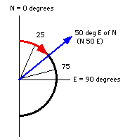
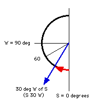
Using a protractor and a ruler, you can draw the angles and distances described in the deed. Note the directions of the protractors shown here.
Since all measures are made with north or south at 0 degrees, begin with that direction. As Birdie Holsclaw suggests, the whole process is easier if you use a full-circle protractor which assigns 0 degrees at both N and S and 90 degrees to both E and W. The marks for the degrees increment from 0 to 90 only instead of the standard protractor's 0 to 180 degrees.
It is challenging, but computer programs are available to do this automatically for you.
You can then create a map of the tract. Note that the beginning and end do not meet. This is not uncommon and represents variations in measuring and compass directions as the surveyor's walked the acreage, as well as inaccuracies in the drawing.
Last update: Thursday, 16-Nov-1995 23:51:44 CST